ASSESSMENT OF COASTAL WATER QUALITY IN BAI TU LONG NATIONAL PARK, QUANG NINH PROVINCE
Joint Vietnam-Russia Tropical Science and Technology Research Center
№ 63, Nguyen Van Huyen Str., Nghia Do ward, Hanoi, Vietnam
Phone: +84 977866230; Email: ntkoanh166@gmail.com
Main Article Content
Abstract
Coastal seawater quality plays an important role in protecting the organisms and life of marine ecosystems. This study evaluates the quality of coastal seawater in Bai Tu Long National Park through field measurements and laboratory analyses. The assessment is based on physical, chemical, and biological parameters, and the results are compared to the standards outlined in QCVN 10:2023/BTNMT. The research team surveyed the research area and selected 25 sampling locations along the coast, encompassing both large and small islands in the Bai Tu Long National Park. According to the measurement and analysis results, the average temperature and salinity of coastal seawater are 27.03 ± 0.46°C and 25.69 ± 1.69‰, respectively; the average values of pH, TSS, and DO are all within the permissible limits. The coastal seawater environment is of high quality to protect the underwater habitat through the pH, DO, and TSS parameters. When compared to the standard, the Fe and P parameters are significantly lower than the permissible limit, safeguarding human health and the marine ecosystem. However, the 8% proportion of low DO readings (<5 mg/L) indicates localized hypoxic conditions, necessitating ongoing site-specific monitoring. The total coliform density in seawater exceeded the allowable limit, with an average density of 1414 ± 266 MPN/100 mL. The primary source of biological pollution in this area is the waste from aquaculture, particularly from fish and mollusk cages. During the sampling, it was observed that the fish in the cages were infected with fungal diseases. It is crucial to take timely measures to address pollution and implement effective solutions for managing the discharge of aquaculture waste in the Bai Tu Long National Park area.
Keywords
Bai Tu Long National Park, coastal seawater environmental quality, biological pollution, Coliform
Article Details
- Highlight
The assessment of coastal water quality in Bai Tu Long National Park was conducted by evaluating physical, chemical, and biological parameters.
Most of the parameters fell within the limits established by QCVN 10:2023/BTNMT, indicating that water quality supports the life activities of aquatic organisms. However, the total coliform levels exceeded the allowable limit.
One significant contributor to coastal seawater pollution is waste from aquaculture activities. To address this issue, effective measures are needed to improve water quality and better manage aquaculture operations in the Bai Tu Long National Park area.
1. INTRODUCTION
Marine ecosystems are the largest aquatic ecosystems in the world. Coastal regions support numerous vital marine ecosystems that significantly contribute to human activities, both industrial and recreational. These ecosystems serve as critical habitats for numerous fish and other marine organisms, which are important food sources for other components of marine ecosystems, as well as food sources for humans [1]. People believe that the biodiversity of coastal areas surpasses that of open seas [2]. The quality of coastal seawater plays a vital role in protecting the organisms and life of marine ecosystems, as well as the health of people in the region and the safety of industries such as aquaculture. However, the influence of human activities has altered this area over time [3]. Excessive nutrient inputs from anthropogenic sources often lead to global issues such as eutrophication and harmful algal blooms, posing serious threats to coastal marine ecosystems [4].
Marine environmental quality assessments are often carried out by measuring the causes of pollution and impacts on the marine ecosystem. Data from monitoring programs serve multiple purposes: compliance monitoring to ensure pollutant levels remain within legal limits, model validation to predict environmental effects, and trend analysis for detecting long-term change. Marine water quality monitoring programs include the collection of data on physical, chemical, and biological variables, such as salinity, turbidity, dissolved oxygen (DO), chlorophyll a, and total coliform bacteria. Additionally, assessments of marine water quality also take socioeconomic data into account [5].
Bai Tu Long National Park, located in the coastal area of the Van Don district, Quang Ninh province, is one of the seven national parks with a sea area in Vietnam. This place possesses high biodiversity value and an extremely unique landscape. The ASEAN Center for Biodiversity recognized the National Park as an ASEAN Heritage Park in 2017 because it satisfied six criteria: ecological integrity, representativeness, naturalness, high conservation value, conservation management plan, and legality. The total natural area of Bai Tu Long National Park spans 15,783 hectares, encompassing both medium terrestrial and sea areas. This area preserves the unique characteristics of the Northeast marine and island ecosystem, home to a variety of species, including endangered and precious species, which are considered rare according to conservation classification scales recognized by Quang Ninh province, Vietnam, and the world. At the same time, Bai Tu Long National Park provides numerous benefits for human economic and recreational activities, including aquaculture, fishing, and tourism. According to Bai Tu Long National Park's management regulations, tourism, fishing, and aquaculture activities are conditionally permitted in specific areas of the marine reserve. Waste from aquaculture, port, and tourism activities is a source of marine pollution. Aquaculture operations can pollute nearby waters with fish wastes, uneaten food, anti-parasite chemicals, plastics, and antibiotics [6]. It is essential to conduct studies on the quality of the coastal marine water environment in this area.
This study focused on monitoring the coastal marine water quality in Bai Tu Long National Park, specifically examining the following parameters: salinity, turbidity, pH, dissolved oxygen (DO), total suspended solids (TSS), total nitrogen (TN), total phosphorus (TP), total iron (Fe), total coliform, and chlorophyll-a. The results from field measurements and laboratory analysis were closely compared with the limit values stated in the National Technical Regulation on Seawater Quality (QCVN 10:2023/BTNMT). This comparison aimed to evaluate the quality of coastal seawater in Bai Tu Long National Park. Through this, the impact of human activities on the coastal seawater environment here can be assessed. The assessment of the current state of the coastal seawater environment is the basis for the protection of habitats for organisms in the marine ecosystem, and informing conservation efforts in Bai Tu Long National Park.
2. MATERIALS AND METHODS
2.1. Research materials
The research team surveyed the research area and selected 25 sampling locations along the coast, encompassing both large and small islands in the Bai Tu Long National Park. These locations are representative of the coastal waters within the park. Figure 1 and Table 1 display the sampling locations and their coordinates. The survey and sampling were carried out in October 2024.
Table 1. Coordinates of sampling points
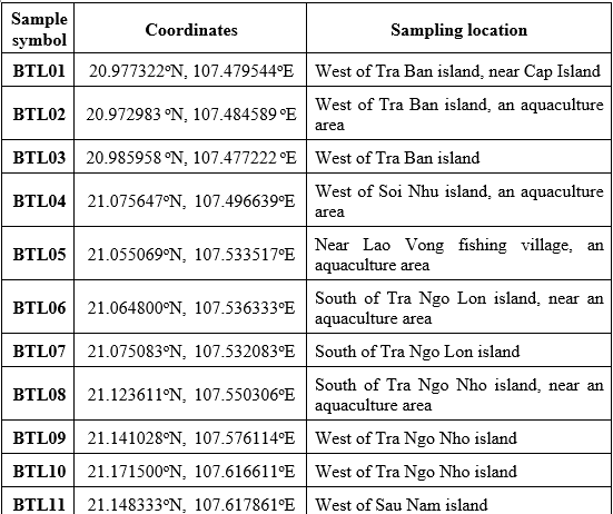
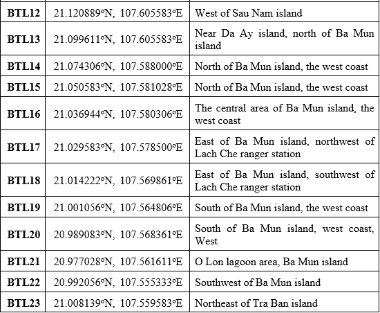
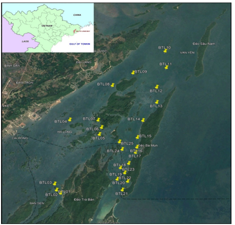
Figure 1.Diagram of coastal seawater sampling points in Bai Tu Long National Park
2.2. Research methodology
At each point, take at least 3 samples at depths of 0.5m, 1m and 2m, then mix well and take 1 representative sample for the sampling point. At each point, water samples were collected in accordance with TCVN 6663-1:2011 and TCVN 5998:1995 standards. The water samples were preliminarily treated and preserved following TCVN 6663-3:2016, TCVN 6663-3:2016 standards. Parameters such as temperature, salinity, turbidity, pH, and dissolved oxygen (DO) were measured in the field using the TOA WQC multiparameter water quality meter. The parameters of total suspended solids (TSS), total nitrogen (TN), total phosphorus (TP), total iron (Fe), total coliform, and chlorophyll a were analyzed in the laboratory with the method presented in Table 2.
Table 2. Methods of analyzing water quality indicators
2.3. Data processing method
The results were analyzed using Excel and SPSS 20 software to calculate the mean and standard deviation (SD) of the measured data and to create a graph displaying the calculated values. Following this, the values of environmental parameters are compared with the National Technical Regulation on Seawater Quality (QCVN 10:2023/BTNMT) to assess the quality of the coastal seawater in Bai Tu Long National Park.
To evaluate the stability of water quality parameters, we will analyze the coefficient of variation (CV). The CV is calculated using the formula:
![]() (1)
(1)
where: CV: the coefficient of variation;
SD: the standard deviation;
Mean:the average value of the parameter.
Assuming a normal distribution, we can estimate the probability of exceeding the standard threshold by using the Z-score, which can be found in the standardized normal distribution table. The formula for calculating the Z-score is as follows:
![]() (2)
(2)
where: Zscore: provisional Z-score
Xst: standard threshold value;
SD: the standard deviation;
Mean:the average value of the parameter
3. RESULTS
Physical Parameters
Temperature: The average surface temperature of coastal seawater in Bai Tu Long National Park was 27.03 ± 0.46°C. The sampling points BTL5 and BTL7 recorded the highest temperature of 27.90°C, while the lowest was 26.10°C at BTL16. In general, the seawater temperature at the coastal water surface of Bai Tu Long National Park is stable, with a coefficient of variation (CV) of 1.17%.
Salinity: The salinity in seawater also showed stability, with a (CV) of 6.60%. The average salinity was 25.69 ± 1.69‰, ranging from 22.40‰ to 29.70‰ across the sampling sites, indicating stable salinity levels.
Turbidity: The turbidity value in coastal seawater shows significant variability, with a coefficient of variation (CV) of 36.70%. The average turbidity value in coastal seawater of Bai Tu Long National Park is 9.63 NTU. At BTL 11, the highest turbidity value recorded was 22 NTU, which was over two times higher than the average value. The lowest turbidity value was 5 NTU, nearly twice the average value.
Physical parameters such as temperature, salinity, and turbidity do not have specific limit values set by the National Technical Regulation on Seawater Quality (QCVN 10:2023/BTNMT). However, when the measured results are compared with the National Standard on Aquaculture Water-Seawater (TCVN 13951:2024), the coastal seawater of Bai Tu Long National Park is found to be of good quality, making it suitable for the growth and development of aquatic species.
Parameters of coastal water quality for protecting aquatic habitats
pH: The average pH value of coastal seawater in Bai Tu Long National Park was 7.5 ± 0.05, compared to QCVN 10:2023/BTNMT, all sample points had pH values within the permissible quality limit value of the pH parameter to protect the aquatic habitat in coastal waters. In the coastal waters of Bai Tu Long National Park, the coastal seawater environment is stable in pH, with a (CV) of 0.67%; the pH values measured at 25 points range from 7.4 to 7.7.
Dissolved oxygen (DO): The average DO concentration was 5.82 ± 0.44 mg/L, compared to the allowable dissolved oxygen (DO) limit set by QCVN 10:2023/BTNMT. The coastal seawater at Bai Tu Long National Park is of good quality and suitable for aquatic life and underwater ecosystems. The concentration of dissolved oxygen in the water remained stable, exhibiting a coefficient of variation (CV) of 7.60%. The dissolved oxygen (DO) values measured at the sampling points primarily fluctuated between 5.5 and 6.5 mg/L. The distribution of these values formed a normal curve, with a peak occurring in the range above the standard threshold (Figure 2). The reference line at 5 mg/L shows that only a small part of the frequency column is on the left, corresponding to 8% of the measuring points with DO lower than this threshold. The theoretical estimate of the probability of exceeding the standard, based on the normal distribution (Z-score = –1.86), yields a result of approximately 3%. This result is lower than the actual monitoring rate, indicating that the observed distribution is slightly skewed towards lower values than expected under a normal distribution. The lowest DO concentration was recorded at BTL5 (4.67 mg/L), located within the aquaculture group, while the highest DO concentration occurred at BTL1 (6.44 mg/L) in the non-aquaculture group. The DO value at BTL5 was approximately 27.5% lower than that at BTL1, highlighting a notable difference between sites with aquaculture activities and those without.
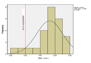
Figure 2. Frequency distribution of dissolved oxygen (DO) concentration
Total suspended solids (TSS): Total suspended solids in seawater correlate with phytoplankton abundance, with low TSS having high abundance [7]. The average TSS concentration was 7.62 ± 2.40 mg/L, much lower than the permissible limit according to QCVN 10:2023/BTNMT, which is 50 mg/L - the quality of seawater suitable for aquatic species to live. TSS of seawater samples taken in the coastal waters of Bai Tu Long National Park ranged from 4.30 mg/L to 12.15 mg/L (Figure 3). However, TSS values in coastal seawater fluctuated strongly between sampling points in Bai Tu Long National Park, with a coefficient of variation (CV) of 31.52%.
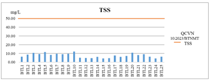
Figure 3.TSS in the coastal seawater of Bai Tu Long National Park
Coliform
Biological parameters are evaluated through the Coliform parameter. The analysis results show that the average Coliform density in seawater in the coastal waters of Bai Tu Long National Park was 1414 ± 266 MPN/10mL. At the sampling points, the Coliform density ranged from 1024 MPN/100 mL to 1815 MPN/10mL, all of which had Coliform values exceeding the permissible limit according to QCVN 10:2023/BTNMT of 1000 MPN/100 mL, in which the two most frequent ranges were 1000-1100 and 1500-1600 MPN/10 mL (Figure 4). Coliform density in coastal seawater of Bai Tu Long National Park was less dispersed among sampling points, with a (CV) of 18.78%. This result reflects widespread microbiological contamination, indicating a potential risk to public health and water quality.
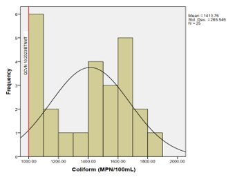
Figure 4.Coliform density in the seawater of the coastal zone of Bai Tu Long National Park
The study divided 25 sampling points into two groups to assess human impacts on coastal water quality: a group of sampling points in aquaculture areas (BLT2, 4-6, 8) and a group of points in non-aquaculture areas (the remaining points). The mean DO concentration in aquaculture areas was 5.47 ± 0.59 mg/L, which was lower than that in non-aquaculture areas (5.90 ± 0.37 mg/L). The dissolved oxygen concentration of the group of sampling points with aquaculture activities recorded a larger variation (± 2SD), indicating a wider dispersion of values (Figure 5). The mean Coliform density at sites with aquaculture activities was 1,312 ± 234 MPN/10 mL, which did not differ significantly from sites without aquaculture, where the mean Coliform density was 1,439 ± 272 MPN/10mL (Figure 5).
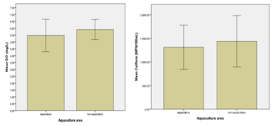
Figure 5.Comparison of dissolved oxygen and coliform concentrations between aquaculture and non-aquaculture areas
Chemical and biochemical parameters
Chlorophyll a: The average concentration of Chlorophyll a in seawater in the coastal waters of Bai Tu Long National Park was 1.16 ± 0.44 mg/m³. Among the 25 sampling points, point BTL6 has the lowest concentration of Chlorophyll a in seawater at 0.36 mg/m³, and point BTL9 has the highest concentration of Chlorophyll a in seawater at 1.86 mg/m³.
Total Fe: The concentration of total Fe in coastal waters is also many times lower than the provisions in QCVN 10:2023/BTNMT; the average concentration of total iron in seawater was 0.01 ± 0.008 mg/L, nearly 50 times lower than the permissible limit of 0.5 mg/L. The highest and lowest total iron values recorded in this area were 0.01 mg/L and 0.05 mg/L, respectively. According to QCVN 10:2023/BTNMT, in terms of total iron parameters, the seawater in the coastal waters of Bai Tu Long National Park is very good quality, protecting human health and marine ecosystems. However, iron (Fe) is an essential micronutrient for marine organisms, and it is now well established that low Fe availability controls phytoplankton productivity, community structure, and ecosystem functioning in vast regions of the global ocean [8]. The iron concentration in Bai Tu Long National Park is very low, which could negatively impact phytoplankton productivity, community structure, and ecosystem functioning.
Nutritional parameters: According to the analysis results, the average concentration of total nitrogen in seawater in the coastal waters of Bai Tu Long National Park was 2.35 ± 0.93 mg/L. The concentration of total phosphorus (TP) in seawater in the coastal waters of Bai Tu Long National Park ranged from 0.01 to 0.02 mg/L. TP and TN are key nutrients whose excessive presence can lead to water body eutrophication [9]. According to QCVN 10:2023/BTNMT, only the limit value of the phosphate parameter (PO43- calculated by P) in coastal seawater is 0.2 mg/L, while the concentration of total phosphorus (including phosphate and other insoluble phosphorus forms) in seawater in coastal waters of Bai Tu Long National Park was 0.01 ± 0.004 mg/L, lower than 20 compared to the prescribed regulations.
4. DISCUSSION
In general, the quality of coastal seawater in Bai Tu Long National Park is good when assessed through individual indicators, including temperature, salinity, turbidity, pH, dissolved oxygen (DO), total suspended solids (TSS), total iron (Fe), and total phosphorus (P). The concentration of iron in seawater is notably low, being 50 times less than the limit established by QCVN 10:2023/BTNMT. In comparing the research results with those from the monitoring conducted by the Bai Tu Long National Park Management Board, it was found that the pH value in October 2024 was lower than the pH value recorded by the Management Board in 2023, which ranged from 7.99 to 8.15 [10]. The recorded DO value was also lower than the monitoring results of the Bai Tu Long National Park Management Board, which ranged from 7.44 to 7.88 mg/L [10]. Dissolved oxygen (DO) levels in coastal seawater tend to decrease and are approaching the lower limit of the allowable limit according to QCVN 10:2023/BTNMT, especially in areas where aquaculture activities are allowed. The coefficient of variation (CV) for DO was 7.6%, indicating relatively stable DO across the sampling network. However, the observed proportion of low DO measurements (< 5 mg/L) was 8%, exceeding the theoretical probability (3%) estimated from the normal distribution. This discrepancy suggests that certain low-DO occurrences are associated with localized environmental factors rather than random variation. The slight skew towards lower values supports the possibility of small-scale hypoxic zones, particularly in aquaculture areas. Continued site-specific monitoring of DO, especially in locations with aquaculture activities, is important for early detection of oxygen depletion events and for maintaining suitable conditions for marine organisms. The parameters of turbidity and total suspended solids (TSS) show a coefficient of variation (CV) greater than 30%, indicating instability. Notably, BTL11 has the highest turbidity value, while BTL10 has the highest TSS value. These sampling points are located in the strait between Sau Nam Island and Tra Ngo Nho Island. It is important to continue monitoring these parameters, along with factors related to ocean currents, when assessing the quality of coastal seawater in this area.
Numerous studies have shown that Coliform concentrations in water within coastal aquaculture areas exceed the permissible limits set by QCVN 10:2023/BTNMT, highlighting the significant impact of aquaculture activities on coastal seawater quality. In some coastal waters in the northern region during 2021, Coliform density was recorded to exceed the permissible threshold, such as in Cua Luc (Quang Ninh), which was 1462 CFU/100 mL; Do Son (Hai Phong), which was 2500 CFU/100 mL; and Ba Lat (Nam Dinh), which was 2850 CFU/100 mL [11]. Tran Quang Thu et al. conducted research on environmental issues in Cat Ba-Hai Phong and Long Son-Vung Tau sea fish cage farming areas, recording that the Coliform density at the Ben Beo (Cat Ba) farming site exceeded 1.2-1.6 times the permissible limit according to QCVN 10:2023/BTNMT, with a high Coliform density in the period 2018-2021. In Long Son, from 2016 to 2021, high Coliform concentrations exceeded the permissible limit in both the dry and rainy seasons [12].
In Bai Tu Long National Park, aquaculture and seafood exploitation activities are permitted within the designated development area, provided that all general regulations are strictly followed. In the study area, fishermen primarily engage in aquaculture activities, including cage fish farming and krill farming. Out of the 25 seawater samples collected at Bai Tu Long National Park, four samples, specifically BTL2, BTL4-6, and BTL8 were collected from locations close to the aquaculture area. The physical parameters, total suspended solids (TSS), and total phosphorus of the seawater meet the conditions for aquaculture activities in the approved areas. However, the coastal waters of Bai Tu Long National Park are polluted by coliform organisms, similar to some other coastal waters in the North. According to the results of environmental monitoring in the aquaculture region in a number of key provinces in the North, including the Van Don area (Quang Ninh), the density of Coliform in krill farming water is 26-125 times higher than the permissible limit [13]. At the time of sampling, coastal seawater in Bai Tu Long National Park was contaminated with microorganisms, as indicated by a total coliform concentration of 1414 ± 266 MPN/100 mL, which exceeds the permissible threshold. A study conducted by Nguyen Huu Nghia in 2022 found that oysters farmed in Dong Xa, Van Don, and Ha Long (Quang Ninh) contained the parasite Perkinsus, as well as seven species of Vibrio spp. Bacteria [14]. At the time of the survey and sampling, the research team noted that a number of fish farmed in the Bai Tu Long National Park area were suffering from fungal diseases (Figure 6). Organisms pollute the seawater environment in aquaculture, causing harm to the farmed organisms. Therefore, more comprehensive studies on the extent of microbial pollution in both aquaculture areas and the coastal marine area of Bai Tu Long National Park need to be conducted. Simultaneously, steps are being taken to treat the seawater environment in aquaculture to maintain its quality and to prevent large-scale pollution in the research area and its surrounding areas.
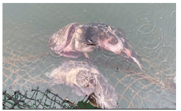
Figure 6.Fish infected with fungal diseases in the cage aquaculture system
This study offers a database on coastal water quality in Bai Tu Long National Park, serving as a resource for managers to formulate policies aimed at safeguarding the coastal marine environment, promoting the conservation of marine ecosystems in the park, and fostering the growth of aquaculture in the area. However, the research remains restricted as it solely focuses on the sampling and analysis of seawater quality at specific locations, neglecting to integrate the comprehensive evaluation of water quality across space and time. The study fails to consider the influence of natural conditions on water quality assessment. Currently, many studies have used remote sensing data, mapping methods, and GIS to assess and monitor water quality, such as the research of Dung T.N. (2024), who used Sentinel-2 satellite imagery to build a model to estimate the concentration of Chlorophyll a in the surface water of the Hinh River Basin [15]; Tran Anh Tuan (2018) studied the distribution of turbidity content in the coastal waters of Southwest Vietnam using remote sensing data and GIS [16]. In future studies, the results of this research can serve as a baseline to evaluate changes in marine water quality over time. Additionally, remote sensing data tools, mapping techniques, and GIS can be utilized to create a comprehensive map of the current status of marine water quality.
5. CONCLUSION
According to the regulations on seawater quality in QCVN 10:2023/BTNMT, the coastal seawater of Bai Tu Long National Park ensures the quality to protect the water environment for the parameters of pH, TSS, and DO, in which the average pH value is 6.5 ± 0.05, and the average TSS is 7.62 ± 2.40 mg/L, and the average DO is 5.82 ± 0.44 mg/L. The parameters of turbidity and total suspended solids (TSS) show a coefficient of variation (CV) greater than 30%, indicating instability. The physical parameters all ensure the environmental quality for the life activities of aquatic species. However, aquaculture activities significantly affect the quality of the coastal water environment in Bai Tu Long National Park. Generally, sampling points near aquaculture show lower average DO values compared to areas without aquaculture. The concentration of coliform bacteria has exceeded the permissible threshold, leading to pollution in the study area. The primary cause of biological pollution here is waste from aquaculture activities. Additionally, cases of fungal diseases have been recorded in fish farming cages. Further research into biological pollution in this area is essential, and timely treatment measures are necessary.
The research findings provide essential information for managing coastal water quality to protect the habitat of aquatic species in Bai Tu Long National Park. Additionally, the study highlights the effects of aquaculture activities on coastal water quality. This information enables managers to develop and guide aquaculture practices that do not compromise the living environment of these aquatic species. However, the study only evaluates the quality of the seawater environment at individual points, without assessing the overall quality across space and time. By combining this database with remote sensing data, mapping techniques, and Geographic Information Systems (GIS), researchers can create extensive maps of the current status of marine water quality. This approach opens up new directions for future research.
Acknowledgments: The paper was completed based on data from the project "Research on assessing ecosystem services for biodiversity conservation and rational use of natural resources in Bai Tu Long National Park, Quang Ninh province" chaired by the Institute of Tropical Ecology, Joint Vietnam-Russia Tropical Science and Technology Research Center.
Conflict of interest statement: The research was carried out from the funding source of the topic "Research on assessing ecosystem services for biodiversity conservation and rational use of natural resources in Bai Tu Long National Park, Quang Ninh province" chaired by the Institute of Tropical Ecology, Vietnam - Russia Joint Center for Tropical Science and Technology Research.
References
2. J.S. Gray, Marine biodiversity: patterns, threats and conservation needs, Biodiversity & Conservation, Vol. 6, Jan., pp. 153-1751997. DOI: 10.1023/A:1018335901847
3. P.M. Vitousek, H.A. Mooney, J. Lubchenco and J.M. Melillo, Human domination on earth's ecosystems, Science, Vol. 277, Issue 5352, pp. 494-499, 1997. DOI: 10.1126/science.277.5325.494
4. D.M. Anderson, P.M. Glibert and J.M. Burkholder, Harmful algal blooms and eutrophication: nutrient sources, composition and consequences, Estuaries, Vol. 25, Aug., pp. 704-726, 2002. DOI: 10.1007/BF02804901
5. Michael Karydis, Dimitra Kitsiou, Marine water quality monitoring: A review, Marine Pollution Bulletin, Vol. 77, Issues 1-2, pp. 23-36, 2013. DOI: 10.1016/j.marpolbul.2013.09.012
6. Judith S. Weis, Marine pollution, 2nd ed.. New York, Oxford University Press, 2024, 352 p.
7. Sew, Genevieve and Peter Todd, Effects of salinity and suspended solids on tropical phytoplankton mesocosm communities, Tropical Conservation Science, Vol. 13, pp. 1-11, 2020. DOI:10.1177/1940082920939760
8. Gledhill, Martha and Kristen N. Buck, The organic complexation of iron in the marine environment: a review, Frontiers in microbiology, Vol. 3, Article 69, Feb., 2012. DOI: 10.3389/fmicb.2012.00069
9. X.E. Yang, X. Wu, H.L. Hao and Z.L. He, Mechanisms and assessment of water eutrophication, Journal of Zhejiang University. SCIENCE. B, Vol. 9, Mar., pp. 197-209, 2008. DOI: 10.1631/jzus.B0710626
10. Quang Ninh Provincial People's Committee, Scientific Proceedings of the 2023 Scientific and Technological Research Summary Conference of Bai Tu Long National Park Management Board, pp. 77-83, 2023.
11. Duong Thanh Nghi et al, The status of sea water environmental quality in the Vietnamese coast in 2021 in Proceedings of the International Conference "East Sea 2022". Century of Marine Science and Technology for the Future of the Ocean. Hanoi, Natural Science and Technology Publishing House, 2022, pp. 431-443.
12. Tran Quang Thu, Nguyen Duc Cu, Duong Thanh Nghi and Nguyen Xuan Sang, Some environmental issues in Cat Ba - Hai Phong and Long Son - Vung Tau sea cage fish farming areas, Journal of Marine Science and Technology, No. 76, Nov., pp. 90-96, 2023.
13. Aquaculture Research Institute I, Northern Center for Environmental Monitoring and Aquatic Diseases, Report on Environmental Monitoring Results of aquaculture in some key provinces in the North in 09/2022, 2022. [Online]. Available: http://www.ria1.org/Defaults.aspx?ctl=newsdetail&LangID=1&p=1.103&aID=2566&stID=434.
14. Nguyen Huu Nghi et al, Environmental and Disease Monitoring in the Northern Aquaculture Area, Version B of the Vietnam Journal of Science and Technology, Vol. 64, No. 9, Sep., pp. 54-59, 2022. DOI: 10.31276/VJST.64(9).54-59
15. T.N. Dung et al, The application of Sentinel-2 satellite imagery to construct a model to estimate the concentration of Chlorophyll-a in surface water in the Hinh River basin, Vietnam, Modeling Earth Systems and Environment, Vol. 10, No. 4, pp. 5813-5829, 2024. DOI:10.1007/s40808-024-02102-3
16. Tran Anh Tuan, Tran Thi Thanh Tam, Le Dinh Nam, Nguyen Thuy Linh, Do Ngoc Thuc and Pham Hong Cuong, Study on the distribution of turbidity content in the coastal waters of Southwest Vietnam by remote sensing and GIS data, Journal of Hydrometeorology, No. 694, Oct., pp. 46-54, 2018.